

This auction is live!
You need to be registered and approved to bid at this auction.
Watch the auction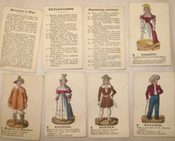
Documents, Prints, Maps, Original Artwork etc.
|
Auction currency
|
GBP |
|
Accepted cards
|
Confirming your bid is a legally binding obligation to purchase and pay for the lot should your bid be successful.
Confirming your bid is a legally binding obligation to purchase and pay for the lot should your bid be successful.
![[MAPS] 6 maps, charts & a view relating to SOUTH AFRICA (6)](https://cdn.globalauctionplatform.com/auctions-2021/srjo10315/images/a4827cc5-54da-4679-8a55-ad7500efa027.jpg?h=175)
![[MAPS] 5 maps & views of CONSTANTINOPLE (5)](https://cdn.globalauctionplatform.com/auctions-2021/srjo10315/images/6c83ec0a-4a3d-4d0b-a261-ad7500efa0fe.jpg?h=175)
![[ASTRONOMY] 9 small hand-col'd plates by Thomas, and 2 others including a Moon Chart (11)](https://cdn.globalauctionplatform.com/auctions-2021/srjo10315/images/a6b9315c-34e7-4663-bc4a-ad7500efa1ae.jpg?h=175)
![[PRINTS] a collection of portraits and views (63)](https://cdn.globalauctionplatform.com/auctions-2021/srjo10315/images/a5e48e40-eee4-47ec-b0da-ad7500efa275.jpg?h=175)
![[MAPS] 4 maps relating to GREECE & MACEDONIA (4)](https://cdn.globalauctionplatform.com/auctions-2021/srjo10315/images/dc3d50e4-02ba-4f04-a2ad-ad7500efa322.jpg?h=175)
![[MAPS] 6 Stanford colour maps relating to ASIA (6)](https://cdn.globalauctionplatform.com/auctions-2021/srjo10315/images/3b2c80a9-978a-42bd-9243-ad7500efa3e9.jpg?h=175)
![[MAPS] 6 b/w charts relating to VOYAGES (6)](https://cdn.globalauctionplatform.com/auctions-2021/srjo10315/images/e3bbd647-9fe9-4466-94a1-ad7500efa4c4.jpg?h=175)
![[MAPS] 10 b/w charts and maps relating to SCANDINAVIA (10)](https://cdn.globalauctionplatform.com/auctions-2021/srjo10315/images/5cb834e5-35e4-4608-a10e-ad7500efa57f.jpg?h=175)
![[MAPS] 3 Scandinavian maps: Copenhagen, 1659; Valck's Denmark; Janssonius, Selandiae, small hole. (](https://cdn.globalauctionplatform.com/auctions-2021/srjo10315/images/c23ac0de-dad2-4f92-b439-ad7500efa64b.jpg?h=175)
![[MAPS] 19 mixed maps, plans, etc. of EUROPE, incl. an allegorical title-page with map of Greece,](https://cdn.globalauctionplatform.com/auctions-2021/srjo10315/images/7b3bf375-98e6-4d28-b989-ad7500efa769.jpg?h=175)
![[MAPS] 25 assorted maps & plans of Europe -Germany, Holland, etc. (25)](https://cdn.globalauctionplatform.com/auctions-2021/srjo10315/images/d55c993e-5b3f-4e84-b8b4-ad7500efa868.jpg?h=175)
![[MAPS] 14 assorted maps of the British Isles, some a/f (14)](https://cdn.globalauctionplatform.com/auctions-2021/srjo10315/images/dd6d5afd-c04d-409e-9525-ad7500efa95f.jpg?h=175)
![[MAPS] 14 assorted maps relating to the AMERICAS (14)](https://cdn.globalauctionplatform.com/auctions-2021/srjo10315/images/5b579ba6-0497-4fdb-93ea-ad7500efaa6e.jpg?h=175)
![[MAPS] 12 maps relating to ARABIA, TURKEY, GREECE and SYRIA (12)](https://cdn.globalauctionplatform.com/auctions-2021/srjo10315/images/f69cedce-d2a1-4284-8e73-ad7500efab35.jpg?h=175)
![[MAPS] 12 maps relating to ASIA, Zatta et alia (12)](https://cdn.globalauctionplatform.com/auctions-2021/srjo10315/images/071b3552-be42-4556-8e22-ad7500efac01.jpg?h=175)
![[MAPS & PRINTS] 23 maps, plans and views of LONDON etc. including: ILN chromolithographs, black](https://cdn.globalauctionplatform.com/auctions-2021/srjo10315/images/67368484-be7b-4cbd-bde1-ad7500efad11.jpg?h=175)
![[MAPS - UK] 11 North Country maps, etc., including Pigot's Monmouthshire, Denbigh, Rutland, Chester,](https://cdn.globalauctionplatform.com/auctions-2021/srjo10315/images/29086862-b5f0-46c6-88ec-ad7500efae0c.jpg?h=175)
![[MAPS - UK] 13 Southern County maps, incl. Essex, Middlesex, Surrey, Dorset, etc. (13)](https://cdn.globalauctionplatform.com/auctions-2021/srjo10315/images/8e2bb22d-9505-4b02-b8bc-ad7500efaeef.jpg?h=175)
![[MAPS] 17 maps of parts of FRANCE, some by Sanson & laid on linen, some with library stamps (17)](https://cdn.globalauctionplatform.com/auctions-2021/srjo10315/images/aae43a29-2a58-43d7-b821-ad7500efaff1.jpg?h=175)
![[SATIRE]](https://cdn.globalauctionplatform.com/auctions-2021/srjo10315/images/7a3622e5-8d11-4909-98a9-ad7500efb0dd.jpg?h=175)
![[MARITIME INTEREST] 40 decorative leaves from Thornton's Pilot (40)](https://cdn.globalauctionplatform.com/auctions-2021/srjo10315/images/a114d558-7682-4778-a6ea-ad7500efb197.jpg?h=175)
![[SAVOY]](https://cdn.globalauctionplatform.com/auctions-2021/srjo10315/images/0ee7108a-d24f-4c9c-bdca-ad7500efb28a.jpg?h=175)
![[ITALY] Chart of the approaches to Genova and 11 other maps and views relating to Italy to](https://cdn.globalauctionplatform.com/auctions-2021/srjo10315/images/b4520544-2d97-48f8-8f0a-ad7500efb365.jpg?h=175)
![[FRANCE] 11 maps & views relating to France to include: Carte des Pais Bas; Le Rouge, Tableau](https://cdn.globalauctionplatform.com/auctions-2021/srjo10315/images/e9a09ac0-cee5-4739-bb17-ad7500efb42c.jpg?h=175)
![[PRINTS & POSTERS] 25 mixed decorative prints, various sizes (25)](https://cdn.globalauctionplatform.com/auctions-2021/srjo10315/images/58fd04ee-1c80-4840-ad58-ad7500efb51f.jpg?h=175)
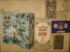
![[MAPS] 15 folding National Geographic maps (world, America, etc.) & 2 AERIAL VIEWS (17)](https://cdn.globalauctionplatform.com/auctions-2021/srjo10315/images/ba6ec40f-cac6-46c7-88a5-ad7500efb5e7.jpg?h=175)
![[MAPS] 4 folding maps: Wigram's Holy-Land; Philip-Stanford Palestine; Bombay - on linen; and](https://cdn.globalauctionplatform.com/auctions-2021/srjo10315/images/6a6c01a5-9555-4872-9967-ad7500efb6a7.jpg?h=175)
![[MAPS, etc.] Carte de L'Empire de Maroc, Paris 1848; Delkeskamp: Atlas Pittoresque du Rhin, 1844;](https://cdn.globalauctionplatform.com/auctions-2021/srjo10315/images/7d756524-71b0-4c46-9e37-ad7500efb78a.jpg?h=175)
![[LONDON] 3 folding maps: Map of the Environs of London; Stanford - Map of the Environs of London; G.](https://cdn.globalauctionplatform.com/auctions-2021/srjo10315/images/1ef5c06a-8db9-41b3-b754-ad7500efb857.jpg?h=175)
![[MAPS] 6 folding maps: LT Bus Map; LT Trolleybus & Tram Map; LU Tramways Guide; Bacon's Cycling Road](https://cdn.globalauctionplatform.com/auctions-2021/srjo10315/images/b5022d6b-4a1a-4db1-bb9c-ad7500efb933.jpg?h=175)
![[LONDON / THAMES] W.H. Smith's Plan of London; and The Oarsman's and Angler's Map of the River](https://cdn.globalauctionplatform.com/auctions-2021/srjo10315/images/77f8a6ca-2026-43d4-a824-ad7500efba40.jpg?h=175)
![[THAMES] Coloured Chart of the Thames Estuary, section 3 only, folding into covers, label; Birds Eye](https://cdn.globalauctionplatform.com/auctions-2021/srjo10315/images/087763ef-742d-493f-bfca-ad7500efbc05.jpg?h=175)
![[LONDON / THAMES] Cruchley's Handy Map of London; and The Oarsman's and Angler's Map of the River](https://cdn.globalauctionplatform.com/auctions-2021/srjo10315/images/5cd1da07-3584-4063-9327-ad7500efbcf3.jpg?h=175)
![[MAP] James Wyld's Folding Plan of London (1)](https://cdn.globalauctionplatform.com/auctions-2021/srjo10315/images/41582dab-2b60-4444-8be9-ad7500efbe1c.jpg?h=175)
![[MAPS] Stanford's New Map of the Parliamentary Divisions & Boroughs of England and Wales; and,](https://cdn.globalauctionplatform.com/auctions-2021/srjo10315/images/28d81e58-f903-42b1-8802-ad7500efbef3.jpg?h=175)
![[MAPS] 4 folding Ordnance Survey Maps Kent and London SE & SW. (4)](https://cdn.globalauctionplatform.com/auctions-2021/srjo10315/images/3103d992-ff23-472b-a990-ad7500efbfa9.jpg?h=175)
![[MAPS] 3 (of 4) folding large maps of the British Isles (North, West, South), in green morocco](https://cdn.globalauctionplatform.com/auctions-2021/srjo10315/images/98578329-ef3b-4f80-9e45-ad7500efc09f.jpg?h=175)
![[MAP] Richardson's New Chart of the British Isles, large folding col. Map (1)](https://cdn.globalauctionplatform.com/auctions-2021/srjo10315/images/086da4ac-5589-4c6a-b30c-ad7500efc15d.jpg?h=175)
![[MAPS - AFRICA] PERTHES (Jules) South Africa [and] Tripoli, sm. Folio with folding maps and](https://cdn.globalauctionplatform.com/auctions-2021/srjo10315/images/dd9bb3f6-cafd-47e9-8065-ad7500efc21d.jpg?h=175)
![[MAP] KARS (J.P.) large (82 x 103 cms) wall map of Greece, wooden rollers](https://cdn.globalauctionplatform.com/auctions-2021/srjo10315/images/76ffeee5-8035-46f5-b058-ad7500efc309.jpg?h=175)
![[MAP] Bacon's New Chart of the World, 95 x 122 cms, laminated, rollers (one off)](https://cdn.globalauctionplatform.com/auctions-2021/srjo10315/images/ab3988f5-e0ea-484a-885a-ad7500efc3e9.jpg?h=175)
![SCHOOL POSTERS, 2, Life on the Shore [and] Fresh Water Creatures (2)](https://cdn.globalauctionplatform.com/auctions-2021/srjo10315/images/ec5895d8-771a-4db5-9f42-ad7500efc50b.jpg?h=175)
![[ASTRONOMY / METEOROLOGY] 21 plates on card from Blunt's](https://cdn.globalauctionplatform.com/auctions-2021/srjo10315/images/b083a498-e553-4149-b7ef-ad7500efc60a.jpg?h=175)
![[MAPS] 7 Black and white maps: S. America, Spain & Portugal, Europe, Scandinavia, Africa and](https://cdn.globalauctionplatform.com/auctions-2021/srjo10315/images/dc98119a-b40b-44a9-9c72-ad7500efc6bf.jpg?h=175)
![[MAPS] 4 folding tourist maps of France, c.1950; Normandy, Brittany, France, & Bordeaux (4)](https://cdn.globalauctionplatform.com/auctions-2021/srjo10315/images/5287df6c-6cbd-4e0a-b664-ad7500efc7b7.jpg?h=175)
![[MAPS etc.] 6 French collectible cards (each 110 x 70 mm) depicting Australian views and customs,](https://cdn.globalauctionplatform.com/auctions-2021/srjo10315/images/b752af32-b350-4986-99b1-ad7500efc8ad.jpg?h=175)
![[MAP] G. F. Cruchley's large, folding wall map of Europe, on four sheets, in slip case (tight)](https://cdn.globalauctionplatform.com/auctions-2021/srjo10315/images/54f9ec79-9ddd-4b7e-aa23-ad7500efc983.jpg?h=175)
![[MAPS] 2 maps of South America: W. Faden's 'Mapa Geografico de America Meridional', 1799, a very](https://cdn.globalauctionplatform.com/auctions-2021/srjo10315/images/19c043f9-ce30-41df-bf1a-ad7500efca69.jpg?h=175)
![[MAPS - LONDON] Stanford's folding map of the Port of London; Bodega, 1879 calendar with map of](https://cdn.globalauctionplatform.com/auctions-2021/srjo10315/images/9c17cca7-98ae-4dda-94c1-ad7500efcb67.jpg?h=175)
![[MAP - CANADA] Stanford's folding map of Canada / British North America, in slip case, 110 x 130](https://cdn.globalauctionplatform.com/auctions-2021/srjo10315/images/f642b104-0bd9-4591-90f8-ad7500efcc39.jpg?h=175)
![[MAP] 'Betts's Tour Through Europe', folding map of Europe, missing board cover](https://cdn.globalauctionplatform.com/auctions-2021/srjo10315/images/c2a97987-c167-4d64-8768-ad7500efccfd.jpg?h=175)
![[MAP - AMERICA] large linen-backed folding Railway Map of the United States, copyrighted 1902-](https://cdn.globalauctionplatform.com/auctions-2021/srjo10315/images/39bc5b1e-a32d-4fad-9d6f-ad7500efcdf3.jpg?h=175)
![[TRAVEL etc.] Souvenir de G nes, bound booklet with 20 photogravure images of Genoa;advertising](https://cdn.globalauctionplatform.com/auctions-2021/srjo10315/images/6bedcda2-1afb-432d-9bdc-ad7500efcebb.jpg?h=175)
![. [BINDINGS] TASSO, La Gerusalemme, 2 vols, 8vo, half calf black and gilt, labels, Paris, Baudry,](https://cdn.globalauctionplatform.com/auctions-2021/srjo10315/images/f917734a-bba1-4976-a538-ad7500efd10e.jpg?h=175)
![[MODERN PHOTOGRAPHY] BRANDT (Bill) Literary Britain, 4to, illus., clo., d.w. (tatty), 1st Edn.,](https://cdn.globalauctionplatform.com/auctions-2021/srjo10315/images/4e575482-c5a5-4428-9bd7-ad7500efd1e6.jpg?h=175)
![[EARLY PHOTOGRAPHY REFERENCE BOOKS] SCHWARTZ (H.) David Octavius Hill, 4to, illus., clo., 1st](https://cdn.globalauctionplatform.com/auctions-2021/srjo10315/images/0f38ef8c-5c10-44ee-a012-ad7500efd2b0.jpg?h=175)
![[PHOTOGRAPHY] MILLER (Lee) Grim Glory, sm. 4to booklet, photo illus., illus. card covers and d.w. (](https://cdn.globalauctionplatform.com/auctions-2021/srjo10315/images/f265898a-b27d-4d4c-8bbf-ad7500efd379.jpg?h=175)
![[PHOTOGRAPHY] BENEDETTA (Mary) Street Markets of London, 8vo, photo-illus by L. Moholy-Nagy,](https://cdn.globalauctionplatform.com/auctions-2021/srjo10315/images/502750c4-9386-4dc6-a626-ad7500efd455.jpg?h=175)